Florieton 1:100 000 topographic map
ARCHIVED
Created 20/01/2025
Updated 20/01/2025
Files and APIs
Tags
Additional Info
| Field | Value |
|---|---|
| Title | Florieton 1:100 000 topographic map |
| Language | eng |
| Licence | Not Specified |
| Landing Page | https://devweb.dga.links.com.au/data/dataset/04faf88e-02e1-4a88-b16d-00cc65c10010 |
| Contact Point | |
| Reference Period | 20/04/2018 |
| Geospatial Coverage |
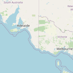   Map data © OpenStreetMap contributors
{
  "coordinates": [
    [
      [
        139.0,
        -34.0
      ],
      [
        139.5,
        -34.0
      ],
      [
        139.5,
        -33.5
      ],
      [
        139.0,
        -33.5
      ],
      [
        139.0,
        -34.0
      ]
    ]
  ],
  "type": "Polygon"
}
|
| Data Portal | Data.gov.au |