Kyneton UDF Town Boundary
ARCHIVED
Created 27/07/2021
Updated 13/11/2024
Files and APIs
-
-
WMSKyneton UDF Town Boundary - Preview this Dataset (WMS)Creative Commons Attribution 2.5 Australia
-
WFSKyneton UDF Town Boundary Web Feature Service API LinkCreative Commons Attribution 2.5 Australia
-
Tags
Additional Info
| Field | Value |
|---|---|
| Title | Kyneton UDF Town Boundary |
| Language | English |
| Licence | Creative Commons Attribution 2.5 Australia |
| Landing Page | https://devweb.dga.links.com.au/data/dataset/36de5218-cd32-4f15-b784-e5778d2a5ba8 |
| Contact Point | |
| Reference Period | 27/07/2021 |
| Geospatial Coverage |
    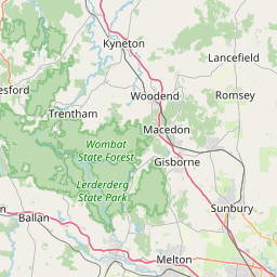     Map data © OpenStreetMap contributors
{
  "coordinates": [
    145.6904167,
    -37.7359722
  ],
  "type": "Point"
}
|
| Data Portal | Data.gov.au |