Northern Wiso Basin Gravity Survey (P201580), gravity point data
ARCHIVED
Created 13/01/2025
Updated 13/01/2025
Files and APIs
-
URLFile available for download in various formats from the GADDS2 portalLicense Not Specified
-
application/x-netcdfNorthern Wiso Basin Gravity Survey (P201580), gravity point data file downloadLicense Not Specified
-
HTMLNorthern Wiso Basin Gravity Survey (P201580), gravity point data OPeNDAPLicense Not Specified
Tags
Additional Info
| Field | Value |
|---|---|
| Title | Northern Wiso Basin Gravity Survey (P201580), gravity point data |
| Language | eng |
| Licence | Not Specified |
| Landing Page | https://devweb.dga.links.com.au/data/dataset/1962baab-83c6-494d-9472-fac46baae37b |
| Contact Point | |
| Reference Period | 18/06/2015 - 09/08/2015 |
| Geospatial Coverage |
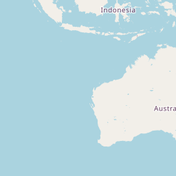    Map data © OpenStreetMap contributors
{
  "coordinates": [
    [
      [
        128.9992,
        -18.9944
      ],
      [
        134.2025,
        -18.9944
      ],
      [
        134.2025,
        -16.7674
      ],
      [
        128.9992,
        -16.7674
      ],
      [
        128.9992,
        -18.9944
      ]
    ]
  ],
  "type": "Polygon"
}
|
| Data Portal | Data.gov.au |