This release consists of flux tower measurements of the exchange of energy and mass between the surface and the atmospheric boundary-layer using eddy covariance techniques. Data were processed using PyFluxPro (v3.4.17) as described by Isaac et al. (2017). PyFluxPro produces a final, gap-filled product with Net Ecosystem Exchange (NEE) partitioned into Gross Primary Productivity (GPP) and Ecosystem Respiration (ER).
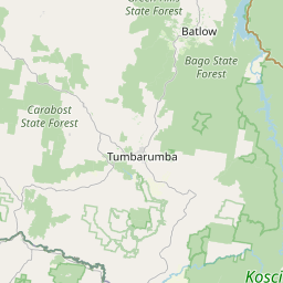
Tumbarumba flux station is located in Bago State Forest in south eastern New South Wales. It was established in 2000 and is managed by CSIRO Marine and Atmospheric Research. The forest is classified as wet sclerophyll, the dominant species is Eucalyptus delegatensis, and average tree height is 40 m. Elevation of the site is 1200 m and mean annual precipitation is 1000 mm. Bago and Maragle State Forests are adjacent to the south west slopes of southern New South Wales and the 48,400 ha of native forest have been managed for wood production for over 100 years. The instrument mast is 70 m tall. Fluxes of heat, water vapour and carbon dioxide are measured using the open-path eddy flux technique. Supplementary measurements above the canopy include temperature, humidity, wind speed, wind direction, rainfall, incoming and reflected shortwave radiation and net radiation. Profiles of temperature, humidity and CO2 are measured at seven levels within the canopy. Soil moisture content is measured using time domain reflectometry. Soil heat fluxes and temperature are also measured. Hyper-spectral radiometric measurements are being used to determine canopy leaf-level properties.